Severe Weather Outlook


new youtube channel - we've just launched a new experimental youtube channel over at tornado HQ, including severe weather outlook videos.
Severe Weather Watches Overview
Watch data currently updates every 15 minutes.

- Severe Thunderstorm Watch #0130 for Central and Northern Arkansas, Missouri Bootheel, Northwest Tennessee
-
- Scattered large hail and isolated very large hail events to 2 inches in diameter possible
- Scattered damaging wind gusts to 65 mph possible
- A tornado or two possible
- Severe Thunderstorm Watch #0129 for Southern Illinois, Southwest Indiana, Western Kentucky, Southeast Missouri
-
- Scattered damaging wind gusts to 70 mph likely
- Isolated large hail events to 1.5 inches in diameter possible
- A tornado or two possible
- Severe Thunderstorm Watch #0128 for Central and North Texas
-
- Scattered large hail likely with isolated very large hail events to 2 inches in diameter possible
- Scattered damaging wind gusts to 65 mph possible
- Severe Thunderstorm Watch #0126 for Western Arkansas, Eastern Oklahoma
-
- Scattered large hail and isolated very large hail events to 2 inches in diameter likely
- Scattered damaging wind gusts to 70 mph likely
↑ back to the list of watches ↑
Severe Thunderstorm Watch #0130
Locations Affected
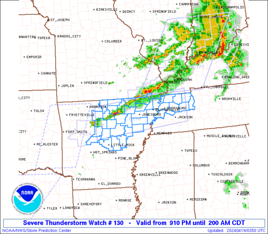
Severe Thunderstorm Watch Summary
Strong to severe thunderstorms are expected to move generally southeastward across the region, with the strongest storms capable of mostly a damaging wind and hail risk through the early overnight.
Severe Weather Threats
Severe Thunderstorm Watch Details
SEL0

URGENT - IMMEDIATE BROADCAST REQUESTED
Severe Thunderstorm Watch Number 130
NWS Storm Prediction Center Norman OK
910 PM CDT Thu Apr 18 2024

The NWS Storm Prediction Center has issued a

* Severe Thunderstorm Watch for portions of
  Central and Northern Arkansas
  Missouri Bootheel
  Northwest Tennessee

* Effective this Thursday night and Friday morning from 910 PM
  until 200 AM CDT.

* Primary threats include...
  Scattered large hail and isolated very large hail events to 2
    inches in diameter possible
  Scattered damaging wind gusts to 65 mph possible
  A tornado or two possible

SUMMARY...Strong to severe thunderstorms are expected to move
generally southeastward across the region, with the strongest storms
capable of mostly a damaging wind and hail risk through the early
overnight.

The severe thunderstorm watch area is approximately along and 45
statute miles north and south of a line from 45 miles south
southwest of Flippin AR to 45 miles northeast of Jackson TN. For a
complete depiction of the watch see the associated watch outline
update (WOUS64 KWNS WOU0).

PRECAUTIONARY/PREPAREDNESS ACTIONS...

REMEMBER...A Severe Thunderstorm Watch means conditions are
favorable for severe thunderstorms in and close to the watch area.
Persons in these areas should be on the lookout for threatening
weather conditions and listen for later statements and possible
warnings. Severe thunderstorms can and occasionally do produce
tornadoes.

&&

OTHER WATCH INFORMATION...CONTINUE...WW 126...WW 128...WW 129...

AVIATION...A few severe thunderstorms with hail surface and aloft to
2 inches. Extreme turbulence and surface wind gusts to 55 knots. A
few cumulonimbi with maximum tops to 500. Mean storm motion vector
30025.

...Guyer
↑ back to the list of watches ↑
Severe Thunderstorm Watch #0129
Locations Affected
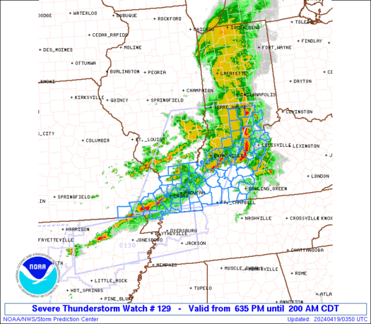
Severe Thunderstorm Watch Summary
Severe storms will continue to steadily move eastward across the region, initially across southern Illinois and southeast Missouri, reaching southwest Indiana/western Kentucky by mid to late evening.
Severe Weather Threats
Severe Thunderstorm Watch Details
SEL9

URGENT - IMMEDIATE BROADCAST REQUESTED
Severe Thunderstorm Watch Number 129
NWS Storm Prediction Center Norman OK
635 PM CDT Thu Apr 18 2024

The NWS Storm Prediction Center has issued a

* Severe Thunderstorm Watch for portions of
  Southern Illinois
  Southwest Indiana
  Western Kentucky
  Southeast Missouri

* Effective this Thursday night and Friday morning from 635 PM
  until 200 AM CDT.

* Primary threats include...
  Scattered damaging wind gusts to 70 mph likely
  Isolated large hail events to 1.5 inches in diameter possible
  A tornado or two possible

SUMMARY...Severe storms will continue to steadily move eastward
across the region, initially across southern Illinois and southeast
Missouri, reaching southwest Indiana/western Kentucky by mid to late
evening.

The severe thunderstorm watch area is approximately along and 85
statute miles east and west of a line from 35 miles south southwest
of Paducah KY to 5 miles east northeast of Terre Haute IN. For a
complete depiction of the watch see the associated watch outline
update (WOUS64 KWNS WOU9).

PRECAUTIONARY/PREPAREDNESS ACTIONS...

REMEMBER...A Severe Thunderstorm Watch means conditions are
favorable for severe thunderstorms in and close to the watch area.
Persons in these areas should be on the lookout for threatening
weather conditions and listen for later statements and possible
warnings. Severe thunderstorms can and occasionally do produce
tornadoes.

&&

OTHER WATCH INFORMATION...CONTINUE...WW 125...WW 126...WW
127...WW 128...

AVIATION...A few severe thunderstorms with hail surface and aloft to
1.5 inches. Extreme turbulence and surface wind gusts to 60 knots. A
few cumulonimbi with maximum tops to 500. Mean storm motion vector
27035.

...Guyer
↑ back to the list of watches ↑
Severe Thunderstorm Watch #0128
Locations Affected
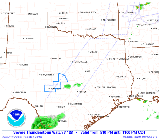
Severe Thunderstorm Watch Summary
At least isolated strong to severe storms are expected to further develop across central Texas, and possibly into additional parts of North/Northeast Texas this evening.
Severe Weather Threats
Severe Thunderstorm Watch Details
SEL8

URGENT - IMMEDIATE BROADCAST REQUESTED
Severe Thunderstorm Watch Number 128
NWS Storm Prediction Center Norman OK
510 PM CDT Thu Apr 18 2024

The NWS Storm Prediction Center has issued a

* Severe Thunderstorm Watch for portions of
  Central and North Texas

* Effective this Thursday afternoon and evening from 510 PM until
  1100 PM CDT.

* Primary threats include...
  Scattered large hail likely with isolated very large hail events
    to 2 inches in diameter possible
  Scattered damaging wind gusts to 65 mph possible

SUMMARY...At least isolated strong to severe storms are expected to
further develop across central Texas, and possibly into additional
parts of North/Northeast Texas this evening.

The severe thunderstorm watch area is approximately along and 65
statute miles east and west of a line from 10 miles west northwest
of Paris TX to 120 miles southwest of Temple TX. For a complete
depiction of the watch see the associated watch outline update
(WOUS64 KWNS WOU8).

PRECAUTIONARY/PREPAREDNESS ACTIONS...

REMEMBER...A Severe Thunderstorm Watch means conditions are
favorable for severe thunderstorms in and close to the watch area.
Persons in these areas should be on the lookout for threatening
weather conditions and listen for later statements and possible
warnings. Severe thunderstorms can and occasionally do produce
tornadoes.

&&

OTHER WATCH INFORMATION...CONTINUE...WW 125...WW 126...WW 127...

AVIATION...A few severe thunderstorms with hail surface and aloft to
2 inches. Extreme turbulence and surface wind gusts to 55 knots. A
few cumulonimbi with maximum tops to 500. Mean storm motion vector
29025.

...Guyer
↑ back to the list of watches ↑
Severe Thunderstorm Watch #0126
Locations Affected
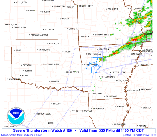
Severe Thunderstorm Watch Summary
Thunderstorms coverage and intensity is expected to increase along a cold front currently moving southeastward across eastern Oklahoma. Robust buoyancy and strong vertical shear will support supercells capable of hail up to 2" in diameter and damaging gusts from 45 to 65 mph.
Severe Weather Threats
Severe Thunderstorm Watch Details
SEL6

URGENT - IMMEDIATE BROADCAST REQUESTED
Severe Thunderstorm Watch Number 126
NWS Storm Prediction Center Norman OK
335 PM CDT Thu Apr 18 2024

The NWS Storm Prediction Center has issued a

* Severe Thunderstorm Watch for portions of
  Western Arkansas
  Eastern Oklahoma

* Effective this Thursday afternoon and evening from 335 PM until
  1100 PM CDT.

* Primary threats include...
  Scattered large hail and isolated very large hail events to 2
    inches in diameter likely
  Scattered damaging wind gusts to 70 mph likely

SUMMARY...Thunderstorms coverage and intensity is expected to
increase along a cold front currently moving southeastward across
eastern Oklahoma. Robust buoyancy and strong vertical shear will
support supercells capable of hail up to 2" in diameter and damaging
gusts from 45 to 65 mph.

The severe thunderstorm watch area is approximately along and 55
statute miles east and west of a line from 25 miles west southwest
of De Queen AR to 30 miles north northeast of Fayetteville AR. For a
complete depiction of the watch see the associated watch outline
update (WOUS64 KWNS WOU6).

PRECAUTIONARY/PREPAREDNESS ACTIONS...

REMEMBER...A Severe Thunderstorm Watch means conditions are
favorable for severe thunderstorms in and close to the watch area.
Persons in these areas should be on the lookout for threatening
weather conditions and listen for later statements and possible
warnings. Severe thunderstorms can and occasionally do produce
tornadoes.

&&

OTHER WATCH INFORMATION...CONTINUE...WW 125...

AVIATION...A few severe thunderstorms with hail surface and aloft to
2 inches. Extreme turbulence and surface wind gusts to 60 knots. A
few cumulonimbi with maximum tops to 500. Mean storm motion vector
27035.

...Mosier
National Risk Overview
- Thursday, April 18
- TORNADO: 5%
- HAIL: 30%
- WIND: 30%
- Friday, April 19
- TORNADO: low
- HAIL: 5%
- WIND: 5%
- Saturday, April 20
- ANY SEVERE: low
- Sunday, April 21
- ANY SEVERE: low / uncertain
- Monday, April 22
- ANY SEVERE: low / uncertain
- Tuesday, April 23
- ANY SEVERE: low / uncertain
- Wednesday, April 24
- ANY SEVERE: low / uncertain
- Thursday, April 25
- ANY SEVERE: low / uncertain
Your Severe Outlook
Hey, it looks like your location wasn't detected.
Drag the marker on the map and we'll show you the severe weather potential for a given location.
Hi, I'm Hayley. Did you know that I run this site out of my own pocket? So if you'd like to help out and you're already planning on buying something off of Amazon, why not use our Amazon Severe Weather Outlook link before you buy and we'll get a tiny portion of your purchase.
About Severe Weather Outlook . com
SWO started as a spinoff project of wickedwx, but has since replaced the site.
- tornado hq - live severe weather warnings
- cyclocane - hurricanes/typhoons/cyclones
- tornado solitaire - play cards while you monitor the US severe weather threat
- tertremo - live view of earthquakes around the world
- earthquake solitaire - get live earthquake updates as you play your favorite card game